Thursday, February 24, 2011

Easter Island, Chile

Thursday, January 20, 2011    78 degrees                              8:00 AM – 5:00 PM
One of the world’s most remote places, Easter Island is a 64-square-mile volcanic island some 2,000 miles from Tahiti and the coast of South America best known for its Moai sculptures (great stone statues). This tiny triangular South Seas outpost measures just 15 miles across and has a population of only 3791. It is a tender port. The island was named by a Dutch navigator, Jacob Roggeveen on Easter Sunday in 1722. The capital is Hanga Roa. The most likely explanation for the island’s decline is that the population outgrew its resources. The food supply failed, the forests were felled and soil began to erode. Without wood for canoes to escape from the island, fighting and cannibalism broke out, and the moai were toppled.
Easter Island today, remains one of the most unique places you will ever encounter; an open air museum showcasing a fascinating, but unfortunately lost, culture. The Rapanui are among the friendliest people you will ever meet, and the landscape is truly amazing – with its volcanic craters, lava formations, beaches, brilliant blue water, and archaeological sites. In late January to early February the islanders celebrate Tapati a festival honoring the Polynesian cultural heritage of the island.
No one knows the true story behind the moai, but they are thought to have been symbols of gods or ancestors. They were carved from around 900 AD out of the soft volcanic rock forming the sides of Rano Raraku crater, where some 400 incomplete pieces remain, many as high a 18 ft. It took 6 men 1 year to carve a statue. Once finished, the moai was cut out of the quarry and transported to a family burial platform called an ahu, some being given red stone “topknots”. Topknots represent hair. The people had long hair which they rolled up in a topknot. The family dead were usually placed in a vault beneath the moai, which was probably believed to transmit mana, or power, to the living family chief. The most famous of the moai are the standing sentinels embedded in the ground on the southern slope of Rano Raraku. These haughty-looking statues remain eyeless; moai were only given coral eyes once they were raised on ahus, at which time the mana began to work.


The most geologically spectacular place on Easter Island is the volcano Rano Kau with its steep crater and multicoloured lake. The ruined village of Orongo sitting on steep cliffs above the crashing sea and three foam-washed islands, is surrounded by rocks with “Bird Man” carvings; a man’s body is drawn with a bird’s head, often holding an egg in one hand. The basis of the cult was finding the first egg laid by the Manu Tara, or sacred bird, each spring. Today there are more than 150 Bird Man carvings in the area, overlaid with fertility symbols.  There is only one moai with eyes.


Nearby are markings and stones that have been interpreted as forming part of a solar observatory, where on the summer solstice the sun can be seen rising over Poike peninsular – one more mysterious attraction on this beautiful and fascinating island in the Pacific.
Aku Akivi Moai – only one facing the sea, no long ears. Natives had light skin, red hair and long ears. Anakena Beach – pristine beauty.
In addition to the statues, the islanders possessed the Rongorongo script; the only written language in Oceania. The island is also home to many petroglyphs (rock carvings), as well as traditional wood carvings, tapa (barkcloth) crafts, tattooing, string figures, dance and music.
There are 887 moai scattered around the island, each one hand-carved from a single piece of stone made of compressed volcanic ash. Some stand on ceremonial stone platforms called abus; others lie on their sides along trails, seemingly abandoned in mid-delivery. Archaeologists have puzzled for generations over the role the moai played in the life of Rapa Nui’s inhabitants. Some believe they were a vehicle for communicating with the gods, others that they were tributes to tribal leaders.
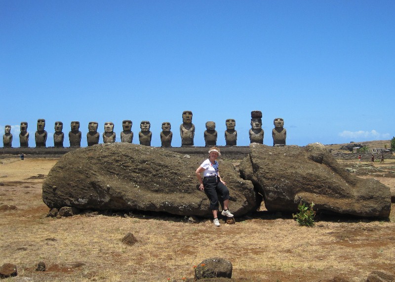
The most striking sites are those where moai stand in groups. Among those are Ahu Tongariki, which includes 15 figures, and Ahu Akivi, where 7 moai keep vigil. Interestingly, the sentinels at Ahu Akivi are the only figures that face the water. One explanation for their positioning is that the seven, as they are sometimes called, represent the seven explorers who discovered the island.
As you walk among the island’s rolling green hills en route to a moai site, you pass monavais, stone greenhouses, used to grow bananas, mangoes, and avocados. Almost everywhere you look you will see wild horses.
Rano Raraku is the quarry area. All the moai were carved here using rock tools, and all those that were carried to resting spots on other parts of the island came along this path. It is mind-boggling to imagine moving the largest of the moai in the shadow of Rano Raraku; nicknamed “El Gigante” , this figure is nearly 72 feet tall and its weight is estimated at more than 145 tons. Rapa Nuans insist that the moai were transported via spiritual power.
“Easter Island: Isolation, Engima and Mystery”, 1914 Katherine Routledge “The Mystery of Easter Island”.


Callo (Lima), Peru

Fri. & Sat. Jan. 14 & 15, 2011    79 degrees                           10:00 AM – 6:00 PM
The harbor of Callao is sheltered by the island of San Lorenzo. It is one of the safest and most spacious in South America. The port is equipped with wharves fit for the simultaneous berthage of more than ten ships, steam cranes, modern warehouses and cold-storage plants, and extensive dry-dock facilities. Chief exports are minerals, cotton, foods, wool and hides.  The port of Callao is 9 miles west of Lima.
Enjoy an overnight call in Peru’s lovely Spanish colonial city of Lima, where sights include gardens and fountains. It is large, noisy, polluted and shrouded in a misty costal fog. Slums on outskirts of Lima populated by Andean immigrants. Montreal is sister city.
Peru, one of the most diverse lands in South America, straddles the Andes Mountains, falling on one side to the Pacific and on the other into the Amazon Basin. Historically, Peru was home to the Incas, one of the most advanced races in the Americas; a people who developed amazing construction techniques as well as sophisticated farming and social infrastructures. Regretfully, their rule ended with the arrival of the Spaniards.
Lima has both decaying colonial splendor and the teeming vitality of an oriental bazaar; melancholy, cloudy winters and warm, breezy summers; impoverished urban sprawl and quiet, elegant corners among ancient buildings where the night air is scented with jasmine. Lima was founded by the Spanish conquistador Francisco Pizarro on Jan. 18, 1535 and is known as the city of kings. It is a city of 9 million people.
The usual starting point for exploring Lima is Plaza Mayor.  A political demonstration was expected the day we were visiting, hence the armed guards.  A The eastern side of the square is dominated by the Cathedral. Opposite stands the Municipalidad de Lima (City Hall). Next to it on the square is the headquarters of the Club de la Union. On the north side of the plaza is the Palacio de Gobierno (Government Palace).  Note the balconies on the Bishop’s Palace which were a major feature of Lima’s architecture during the colonial period. The Historic Center of Lima, made up of Lima and Rimac was declared a World Heritage Site by UNESCO in 1988 due to its importance during the colonial era.


We arrived at the architectural masterpiece, Santo Domingo, one of the oldest convents in Lima. Saint Rose of Lima, Saint Martin de Porres (first black saint) and St. Juan Masias remains are here.

Drove through San Isidro to Miraflores where we stopped to take pictures at Love Park on the Pacific Ocean. Also visited Larcomar Mall located below a beautiful park.


Manta, Ecuador

Wednesday, Jan. 12, 2011    86 degrees                                          6:00 AM – 5:00 PM
Manta is a mid-sized city in Manabi Province, Ecuador.  It is the second most populous city in the province, the fifth most populous in the country and, economically, the third most important city of Ecuador.  Manta has existed since Pre-Columbian times.  It was a trading port for the Mantas.  The city has 192,322 inhabitants.  Its main economic activity is tuna fishing.  It possesses the largest seaport in Ecuador.


The Murcielago senic boardwalk- craft market in Central park.  Saw tagua carvings – a vegetable that looks like a nut and when carved in jewellery resembles ivory.


It serves as a geographical look-out point for the United States for any war craft heading North from the middle East and Asia.  A regular stop for US Navy warships.
            

Panama Canal


The Panama Canal, a masterpiece of engineering, is considered to be the eighth wonder of the modern world and has shortened the trip around the continent of South America by 7,000 miles.  In 1999, the government of Panama was granted full authority of the enterprise.   We enter the canal at Gatun locks.  After crossing Giguel and Miraflores locks.  After transiting these locks we will enter the North Pacific Ocean and continue on a southerly course towards Ecuador.

The Pacific Ocean claimed its namesake from the Latin name Mare Pacificum (peaceful sea), bestowed upon it by the Portuguese explorer Ferdinand Magellan.  For most of Magellan’s voyage from the Strait of Magellan to the Philippines, the explorer did find the ocean peaceful; however, this is not always the case.  Many tropical cyclones (typhoons – the equivalent of Atlantic hurricanes), batter the islands of the Pacific; the lands around the Pacific Rim are full of volcanoes and often affected by earthquakes; tsunamis, caused by underwater earthquakes, have devastated many islands and destroyed entire towns.
The Pacific Ocean encompasses one third of the Earth’s surface, making it the largest body of water with an area of 69.4 million square miles (179.7 million square kilometers), an area significantly larger than the entire Earth’s landmass.  The lowest point on Earth, the Mariana Trench, lies in the Pacific Ocean at 35,797 feet (10,911 meters) below sea level.  The average depth of the entire ocean is 14,000 feet (4,300 meters).

Puerto Limon, Costa Rica

Sunday, January 9, 2011     83 degrees                                               6:00 AM – 5:00 PM

Limon is Costa Rica’s  (shore of riches) busiest Caribbean port and serves as the Caribbean commercial center.  Costa Ricans are affectionately known as tico(a)s for the charming national habit of ending words with the diminutive “tico”.  The national character is best summed up in the favorite local expression – Pura vida! – implying a (temporary) state of utter perfection.
Columbus discovered Costa Rica on his 4th voyage.  The country is full of volcanic mountains, lush valleys, and virginal tropical rainforests supporting a diverse mixture of plant and animal life.  Some of the interesting shore excursions revolve around these national parks or the Costa Rican countryside.
We took a shore excursion to Braulio Carrillo National Park, a preserved tropical virgin rain forest, full of fascinating creatures and plant life, to ride on an aerial tram across the canopy of the rain forest.  The tram is a specially customized ski lift that allows visitors to see the forest from “the top”, where more than half the species live.  We boarded the 7 passenger rain forest aerial tram for a 90 minute ride through the rainforest.  We started on the lower level outbound and were introduced to the sub canopy.  The return journey took us through and above the canopy.  Enjoyed a tasty Costa Rica lunch.  It was a 2 hour bus ride each way from the ship.  On the return journey we saw 2 and 3-toed sloths hanging from the trees.


We began our visit by trekking along their rainforest paths for 45 min.  We saw leaf carrying ants, carrying pieces of leaves larger than themselves.  We saw fish-tail plants that bats use for protection, elephant ear plants, orchids, big lip flowers and monkey ladder said to be more effective for treating diabetes than insulin.         


Tuesday, February 22, 2011

George Town, Grand Cayman

Jan. 7, 2011  80 degrees                                                              8:00 AM – 5:00 PM
We’ve arrived at the first port of call on our voyage.  Grand Cayman is a haven for snorkeling and diving.  Into Grand Cayman by tender which takes approximately 15 minutes.  We could not tender into the cruise ship terminal as the water was rough.  We were tendered into Spotts Bay 3 miles out of Georgetown and then provided with a free shuttle to Georgetown.  Went  to Seven Mile Beach by taxi which is 3 miles from the cruise ship terminal – not to be missed destination. Taxi to Beach $4.00 ea. US.  We went to the Royal Palms Beach Resort.  Great facilities – showers, changing rooms, restrooms, chairs and umbrellas on the beach.  We walked the beach for 1-1/2 hours.


Returned to Georgetown by taxi.  Walked around town and then went to the Tortuga Rum Cake Factory on South Church St. facing the waterfront.  They have free samples of Grand Cayman’s famous rum cake in many different flavours.
Less than ten years ago Grand Cayman was a sleeping British Colony, its only trademarks were its peaceful way of life and its magnificent beaches.  Another distinction for the island is its freedom from taxation.  This tax-exempt status has attracted over 600 banks to the island with a population of approximately 44,000.
The West Coast of Grand Cayman is the most developed with George Town and Seven Mile Beach, its hotels, resorts and condominiums.  Harbour Drive runs

CHRIS & DOREEN 2011 GRAND WORLD VOYAGE


The day has finally arrived for us to begin our 110 day grand world voyage with Holland America Cruise Lines on their flagship the Amsterdam.  We took the shuttle from our hotel to the port and arrived at 11:30 AM on Wednesday, January 5th, 2011.