Monday, May 2, 2011

Wellington, New Zealand

Thursday, February 10,2011    67 degrees                            8:00 AM – 6:00 PM


Choir singing to greet us in port
Wellington is New Zealand’s capital.  Sporty city.  Nestles between the sea and the Tararua Ranges which tower almost 3,000 ft. It stands at the southwestern tip of North Island on Cook Strait, the passage that separates the North and South Islands.    Coloured  roofs cascade down the steep hillsides, creating a vibrant collage against a spectacular green backdrop.  An old brick monastery peers down on a jigsaw of masts and sails in the marina.  Port Nicholson is surely one of the finest natural anchorages in the world.  Known to local Maori as The Great Harbor of Tara, its two massive arms form the “jaws of the fish of Maui”.
We began our day by taking the shuttle bus into downtown Wellington.  We boarded the Kelburn Cable Car and although the ride is only 6 minutes long it affords a beautiful scenic view of Wellington, the New Zealand capital.  The sleek red car caries you up a sheer grade through Mount Victoria to the elevated Kelburn District.  We walked down to Wellington through the Wellington Botanic Gardens and the fragrant Lady Norwood Rose Gardens and the Begonia House.


We walked past the Parliament Buildings (the distinctive “Beehive” and the impressive Old Government Building which is the second largest wooden building in the world.  We walked down to the harbour to the Museum of wellington City and Sea.  The museum is housed in the Bond Store, a listed Category l historic building - important in Wellington’s wharf heritage.  This museum houses 800 years of Wellington is New Zealand’s capital. Nestled between the sea and the Tararua Ranges which tower almost 3,000 feet, it stands at the southwestern tip of North Island on Cook Strait, the passage that separates the North and South Islands.  Coloured roofs cascade down the steep hillsides, creating a vibrant collage against a spectacular green backdrop. An old brick monastery peers down on a jigsaw of masts and sails in the marina. Port Nicholson is surely one of the finest natural anchorages in the world. Known to local Maori as The Great Harbor of Tara, its two massive arms form the “jaws of the fish of Maui”.


The port of Wellington is entered through a passage eight cables wide after which you enter Wellington Harbour, a bay that is four miles wide and deep, with Somes Island in the middle of it.  Wellington is situated on the western side of the bay.  Wellington is the southernmost national capital city of the world, with a latitude of about 41 degrees south.  It is more densely populated than most other settlements in New Zealand, due to the small amount of building space available between the harbour and the surrounding hills.  Because of its location in the roaring forties and its exposure to omnipresent winds coming Wellington’s maitime history:  the sinking of the Wahine inter-island ferry is part of it.  While we were visiting a lady that was on this ferry when it sank in 1968 was addressing a group of teenage school girls.
We continued walking along the harbour to the Te Papa Tongarewa Museum of New Zealand which means “a container of treasures”.  It provides a good introduction to the country’s people, cultures, landforms, flora, fauna.

You don’t need a car to see the city. Civic Square is the heart of town. Lambton Quay is part of a waterfront constructed on land reclaimed from the waters of Port Nicholson and, with Willis Street and Cuba Street, forms a bustling shopping area.  Norfolk pines line the broad sweep of Oriental Bay, a suburb with a small beach and a wide promenade.

Ship docked at Aotea Quay between Inter Island ferry and train station.
    

Sunday, May 1, 2011

Stewart Island, New Zealand

Sunday, February 13, 2011    70 degrees                               8:00 AM – 4:00 PM
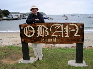
This is a maiden call at Oban, Stewart Island “land of glowing skies” (Aurora Australis). New Zealand’s southernmost community of 300 residents. General store, a hotel and café.The third and most southerly of New Zealand’s main islands. It is separated from the South Island by the 15 mile Foveaux Strait. Seals and penguins frequent the coast. This is the surest place to see a kiwi. The Stewart Island brown kiwi is the largest species of this kind of bird. Unlike their mainland cousins, these kiwis can be seen during the day as well as at night. This island is remote, raw and untouched.
Apart from the tiny township of Oban at Halfmoon Bay on Paterson Inlet, Stewart Island is practically uninhabited.  Most of the 390 islanders live in or around Oban.  Directly behind Oban’s waterfront is a short main street with a small collection of establishments.  New Zealand’s newest national park Rakiura  “The Isle of Glowing Skies” – walkers paradise.  Stewart Island, also known as “the third island”, is one of New Zealand’s most remote destinations.


One of the best places for bird-watching is Ulva Island. The rare birds that live here have no predators, so they have an excellent survival rate. Among the resident species are the weak, the saddleback, kaka (a parrot), and kiwi. The forest, which has walking paths is made up primarily of rimy, rata, and kamahi trees.  We went on a 2 hour guided nature walk here.  The island is managed by the Department of Conservation as an “open sanctuary” where native birds can be seen at close quarters.


2 saddleback birds


Because of size over 400 years old


wild mushrooms


Our ship's captain, Olav van der Waard


Waiting for tender back to ship


Tuesday, April 26, 2011

Funchal, Madeira, Portugal


Panorama of Port of Funchal

Tuesday, April 16, 2011      65 degrees                                                5:30 AM – 3:00 PM

In port at Madeira
       
We set out on a southwesterly course to Madeira.  The Madeira archipelago was discovered by the Portuguese in the 15th century.  At this time the islands were still uninhabited.  After its discovery, the islands have been mainly under Portuguese sovereignty.  All islands in the Madeira archipelago are of volcanic origin.  Because of this, Madeira is mountainous.  The tallest peak on Madeira is Ruivo de Santana.  The harbor of Funchal is mainly used as a passenger terminal for the tourist industry.

The marine approach presents a stunning picture as the colourful and majestic Madeiran peaks suddenly appear from the blue mist.  The island’s mystery begins in beauty, but the enigma is enhanced by suggestions that it may be the remains of the lost continent Atlantis.  Colourful flowers and spectacular waterfalls are the spawn of Madeira’s fertile soil and perfect climate – warmed by Atlantic currents in winter and cooled by trade winds in summer.  Everything seems to grow – and as if to prove the point, a hodgepodge of shrubs and flowers have been imported from all over the world.  It is not a big place – the island is only 35 miles long and 13 miles wide at its widest point, but roads climb and drop precipitously from one ravine to the next, so travel times are longer than expected.  Funchal is named for one of the most fragrant native plants – funcho (fennel).
 Funchal is the capital of the Madeira Islands of Portugal and is also the largest city on the islands.  It was founded by Gonsalves Zarco in 1421 and was elevated to city by King Manuel I in 1508.  It was important as a stopping place between the Indies and the New World, and was known as a wealthy place.  Portugal, located in southwest Europe on the western Iberian Peninsula, includes the Madeira Islands and the Azores in the northern Atlantic Ocean.
 Funchal is graced with an unusually dramatic setting.  At its back, jagged mountains – some 1,200 metres high – encircle the city like a giant amphitheatre, while its feet are lapped by the sea.  The historic core of the capital still overlooks the harbor and boasts fine government buildings and stately 18th C houses with shady courtyards, iron balconies and carved black basalt doorways.  The town has steep cobbled streets and overall air of grandeur.
We toured Funchal on our own this morning.  We boarded the shuttle bus into town and then walked along the harbor to catch the cable car to take us up to Monte.  Opened in 2000, the two mile long Doppelmayr cable route takes approximately 10 minutes in each direction.  As we left the station, the old city comes into view.   As the car climbs above the city we were rewarded with sweeping views of Funchal harbor.   Just below the chuch in Monte we watched people getting in sleighs powered by 2 men which takes you ½ way down to Funchal.
Monte is only 4 miles from Funchal, but nearly 2,000 feet high, in the highest part of a national park, it seems more like heaven.  Austrian Emperor Carlos I is buried at Nossa Senhora do Monte, a hilltop chapel built on the site of the earlier Church of Encarnacao.  When you see the façade of this charming church you cannot resist climbing the 68 steps to see inside.
We took the cable car back down to return to Funchal.  The first place we visited was the famous covered market, the Mercado dos Lavradores.  Built in 1941 it has strong Art Deco overtones.  All the hustle and bustle of Funchalese life is here, spilling out from the arcaded inner courtyard with its dozens of stalls piled high with vegetables, herbs, flowers and exotic fruit. Head through the doors at the eastern end to find the fish market, a good place to make your acquaintance with Madeira’s famous black espada, the eel-like, razor-toothed scabbard fish that crops up on every restaurant menu.
We walked around the downtown area, browsing in the stores and then took the shuttle bus back to the ship a 1 PM.


View of church from cablecar
 
The sleighs of Monte


Watching sleighs from church above

Chris in downtown Funchal


Cadiz, Spain

93 miles southwest of Seville
Sunday, Apr. 17, 2011      65 degrees                          10:00 AM – 11:00 PM
We followed the coast of Spain towards the Strait of Gibraltar which we transited early this morning.  Due to the high amount of traffic transiting this entrance to the Mediterranean, a traffic scheme has been established to ensure all vessels can safely navigate the strait.  After clearing the traffic scheme we headed on a northerly direction towards Cadiz.
Cadiz is a coastal city in southwestern Spain in the region of Andalusia and the capital of the province of Cadiz.  Traditionally, its date of establishment is about 1100 BC, although as of 2004 no archeological finds have been found that date back further than the 9th century BC>  It is regarded as the most ancient extant city in western Europe.
CADIZ  Surrounded by the Atlantic Ocean on three sides, Cadiz was founded as Gadir by Phoenician traders in 1100 BC and claims to be the oldest continuously inhabited city in the Western world.  Hannibal lived in Cadiz for a time, Julius voyage, after which the city became the home base of the Spanish fleet.  Most of its buildings – including the cathedral, built in part with gold and silver from the New World – date from this period.  The old city is African in appearance and immensely intriguing—a cluster of narrow streets opening onto charming small squares.  The golden cupola of the cathedral looms above low white houses and the whole place has a slightly dilapidated air. 


We took a shore excursion “Stunning Seville”.  From Cadiz we had a 1-1/2 hour drive through Andalusia’s cork plantations to Spain’s 4th largest city, Seville.  It  is the capital of Andulusia, and has a Muslim heritage.  Seville’s whitewashed houses bright with bougainvillea, its ocher-coloured palaces, and its baroque facades have long enchanted both Sevillanos and travelers.  Seville oranges are too bitter to eat except as Scottish-made marmalade. 
Seville throws the most spectacular fiesta in all of Spain during Holy Week, between Palm Sunday and Easter, followed by the decidedly more secular Feria de Abril, starring horses and bullfights. 
Our coach let us off at the Spanish Square.  From there we walked to Pilot’s House, which is a normal family residence fashioned after the Alcazar.  It has Moorish, Italian and Renaissance influence (Roman sculptures).  It is known as Pilot’s House because Don Fadrique allegedly modeled it on Pontius Pilate’s house in Jerusalem where he had gone on a pilgrimage in 1518. 
We went to Pilot’s House instead of the Cathedral as this is Palm Sunday and there will be 60 processions passing through it in the next week.  In the parades the people have special costumes on that cover their faces – to have a private station of penetance.    They have to wear sandals or bare feet.  We went to the Macarena Hotel for a hot and cold buffet lunch.  We then visited the oldest area (the Jewish Quarter).  The twisting alleyways and traditional whitewashed houses add to the tourist charm of this barrio.   We were given ½ an hour to shop in the Santa Cruz quarter with its ceramic tiles and iron railings. 
We next visited the magnificent Alcazar – royal residence – a monument to the Moorish occupation of Spain surrounded by glorious gardens.  The palace is the official Seville residence of the king and queen when they are in town.  We visited the Hall of Justice, the Courtyard of Plaster, and the Court of the Damsels which opened off the Hall of the Ambassadors.  There were ducks in the pond in the garden and well as many, many Carp to keep the water clean. 
We drove the 1-1/2 hours back to the ship where we had a cultural presentation which showcased flamenco dancers.

Cartagena, Spain

Saturday, Apr. 16      67 degrees                                                           8:00 AM – 3:00 PM

Panoramic view of Cartagena

We set out on a southwesterly course towards Bonifacio Strait.  This strait lies between the French island of Corsica and the Italian island of Sardinia.  Both islands are very mountainous and rugged.  Corsica is the most mountainous island in the Mediterranean.  The town of Cartagena is surrounded by several forts, three of which should be visible on our approach standing on the hills surrounding Cartagena.  The forts are called respectively Castillo Atalya, Galeras and San Julian all of them named after the summit they stand on.
Cartagena has long been an important maritime base.  The fortifications are mostly gone, but the port area shows something of its naval history.  Renovated in the Middle Ages, Castillo de la Concepcion was originally a Roman structure.  Lush gardens surround the remains of the castle, and the view is excellent.  A broad seaside esplanade lines the flanking ramparts – built in the  Middle Ages.  The fortified Cathedral also dates from that era.
In 1888, native son Isaac Peral built the small unassuming submarine that rests on the esplanade.  Two 30hp engines powered the machine – the first such vessel ever built.  Other monuments dedicated to modern and historical naval heroes are prominently displayed in the district.  Near the port, the Arsenal is still headquarters to an important Spanish Naval wing.
Along calle Carmen Mayor, the city’s pedestrian-only shopping district.  A section of Custro Santos and several other streets in the old district are also set aside for pedestrians.
We began our day in Cartagena by receiving an invitation to visit Holland America’s newest ship the MS Nieuw Amsterdam which is docked right next to us.  We bypassed the trip because we did not want to wait, but rather visit Cartagena.


Elevator up to Castillo de la Conception (we walked up)


View over Cartagena from castle


Ruins of old Roman theatre
 Began by walking up to the Castillo de la Concepcion Castle.  Castillo de la Conception built by Enrique III in the 14th C using the remains of nearby Roman ruins.  The views from here are astounding, reaching out over the town, harbor, and the Mediterranean.  A  panoramic lift (elevator) on Calle Gisbert rises nearly 150 feet to a gangway that leads to the Conception Castle.  We saw some beautiful peacocks on the lawn in front of the castle.

Across the road, and under Plaza de Toros, are some remains of the Roman Amphitheatre.   We saw the new outdoor theatre as well which is next door.  The Roman Amphitheatre lies where the now abandoned Bull ring was built.


Beautiful marble streets

Walked along Calle Mayor and looked in all the shops.  The sidewalk on this street is marble.  Absolutely beautiful.  The modern harbor promenade, Paseo de Alfonso XII is spectacular.   Passed by city hall, the museum of the Roman theatre and the monument to the heros of Santiago de Cuba. 


Monument to the heros of Santiago de Cuba

Back on the ship we went to the last cocktail party for the Ensemble group.  The Indonesian crew are performing their show for us tonight.

Civitavecchia, Italy

Thursday, April 14, 2011     58 degrees                                               7:00 AM - 6:00 PM


Port of Civitavecchia, Italy
We head out of the Gulf of Naples and after rounding Ischia Island, follow the Italian coast on a northwesterly heading towards Civitavecchia.  Early in the evening we passed the Pontine Islands on our port side at a distance of 3.5 nautical miles.  They are rugged and distinctive in appearance which is further evidence of the volcanic nature of the region in which we are sailing.  Civitavecchia’s harbor is protected by a mole extending 1 mile parallel to the coast.  It is the principal port for Rome, approximately 40 miles away and provides general cargo and container facilities, but is also turning into a major cruise port.
Civitavecchia is located in Latium, west central Italy, on the Tyrrhenian Sea.  Bernini built the Arsenal and Michelangelo directed the final stages of the construction of the powerful citadel beginning in 1508. 
We went on a shore excursion to the ruins of Ostia Antica.  These well-preserved ruins are just 20 miles from Rome.  Scientists estimate the town was founded in the 4th Century BC as a military base, designed to secure the river mouth against possible invasion.  As Roman power rose, the outpost was expanded as the main domestic landing for cargo boats and by the 2nd Century AD, it had become a flourishing commercial center.  Located between Tiber River and Tyrrhenian Sea the  main street runs for more than a mile.  It is named Decumanus Maximus.  Your feet settle into deep ruts left by the four-wheeled carts used to ferry merchandise between Rome and Ostia. 


Just inside the Roman Gate, the Baths of Neptune feature a vivid mosaic.  A rather large piece, the image depicts the sea god driving a horse-drawn chariot.  An ancient amphitheater reveals the towns former importance—not just every village had a theatre.  Dating from 12BC, the preserved structure once accommodated 3,500 spectators.   The Forum of the Corporations is just beyond.  The forum was a commercial center.  Those with goods to ship would shop among the various maritime concerns that had stalls at the site.                                                                                                        
 Apartment buildings, taverns and grocery shops are still intact. Collegiate Temple was a social club for men of the poorer classes.  Laundry shop was next to the public baths.  Hot air piped up from underground boilers.


Went to the new town of Ostica for a gelato.  I had hazlenut which I loved when in Rome years ago.